Westside History by Walker A. Tompkins
 The “Westside Story” of Santa Barbara is laid in our city’s first suburb to be initiated by Anglos rather than Hispanics; the Spanish genesis of the city was located on the Eastside.
In 1850, when the United States annexed California to the Union, the Westside was open grazing range and farmland, turning marshy near the beach. Today this area is solidly overlaid with urban development extending inland to the Goleta Valley, making it the most densely populated neighborhood in Santa Barbara.
The earliest historical reference to the Westside came in 1793 when Captain George Vancouver, a British explorer-scientist who was circumnavigating the globe, anchored the Discovery off West Beach and received permission for his sea cook to chop stove wood from the Mesa oak groves, and refill his water tanks from a seep at the base of the Mesa bluffs near Pershing Park.
Col. Fremont and his California Battalion made bivouac along Mission Creek between Anapamu and Canon Perdido Streets during Christmas week of 1840, resting up for their march to Los Angeles and a final showdown with the Mexican forces at Rancho Cahuenga.
Following California statehood in 1850, Santa Barbara’s Common Council authorized the surveying and naming of our city streets. The ten major north-south streets situated exclusively on the Westside derived their history-oriented nomenclature as follows: Chapala, for a lake in Jalisco Province, Mexico. De la Vina, for the vineyards it crossed. Bath, or Banos, led to the public bathing beach. Castillo pointed toward the Castle Rock landmark. Rancheria crossed one of thirteen local Indian rancherias, or villages. San Pascual was the battlefield where the Mexicans whipped the Yankees. San Andres commemorates Gen. Andres Pico, commander of the Mexican forces. Chino was named for Rancho Santa Ana del Chino, another Southern California battlefield. Gillespie, for Lt. Archibald Gillespie, an American hero of the Battle of San Pasqual. Robbins memorializes Thomas Robbins, a Yankee pioneer who once owned Hope Ranch and Santa Catalina Island.
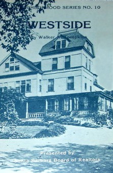
The lower Westside, being well watered, soon became checkered with five-acre (one square block) farms. The first major landowner on the Westside was Judge Albert Packard of Rhode Island, who in the late I880s bought 200 acres fronting on De la Vina between Canon Perdido and Micheltorena, extending up into the Mesa hills.
In 1861 Packard erected a yellow brick mansion at 510 West Canon Perdido Street which in later years was the Joseph Acquistapace home. In 1864 Packard built his famous two-story “La Bodega” or winery near his home, the largest adobe in California. Its vats produced 80,000 gallons of wine annually, which he marketed world wide under the brand name El Recodo, the corner. More than 100 Indians tilled his vineyards. When Anaheim disease destroyed his vines, Packard converted to olives. He also imported Sicilian limes and lemons, and grew Santa Barbara’s first aguacates or Mexican avocados.
In partnership with a Frenchman named Jean Emil Goux, Packard raised silkworms in the attic of his winery, feeding them leaves from mulberry trees which occupied the area where the Castillo Street underpass of U.S. 101 is now located. The sericulture project was not a commercial success, however.
Joseph Sexton, one of California s most prominent horticulturists and nurserymen, moved to Santa Barbara from San Francisco in November 1868 and bought land on the lower Westside. He erected a shanty at the north corner of Montecito and Castillo Streets and planted 1,000 walnut seedlings on what is now Pershing Park. A year later he transplanted them to a forty-acre nursery located in the 5400 block ot Hollister Avenue, Goleta Valley. There he developed his Westside walnuts into “Santa Barbara paper shells,” or soft-shelled walnuts. He also introduced pampas grass, Australian eucalypti and Norfolk Island star pine trees to the Santa Barbara scene.
The decade of the 1860s saw the transition from Spanish adobe to American wood construction, and also the proliferation of brick buildings. This kept several brickyards busy in the Ladera Street corner of the Westside, the most prominent being operated for many years by J.Y. Palmer and the Grant Brothers.
Among the prominent brick landmarks on the Westside was St. Vincent’s Orphanage, built in 1874 at 925 De la Vina Street. Its destruction by fire that same year led to the organization of Santa Barbara’s first volunteer fire department. Rebuilt, the orphanage lost its upper story in the 1925 earthquake, which involved the Mesa Fault on the Westside. The building is now the Knights of Columbus Hall.
Amasa Lincoln, a Boston banker who had purchased the Tajiguas Rancho west of Refugio Bay, moved into town in 1871 and built a New England style boarding house at Sola and De la Vina Streets. Then called the Lincoln House, it remains today the oldest hotel in town under continuous operation, Renamed the Upham Hotel in 1911 by a new owner, it will revert to the name “Lincoln House” in 1981.
Protestant churches found a fertile seedbed in the Westside during the 1870s. Among the pioneer houses of worship were the Methodist Church originally at Bath and Ortega, later at De la Vina and Figueroa; the First Baptist at Ortega and De la Vina the First Presbyterian on State Street near the corner of Anapamu; the Congregationalist north of the Arlington Hotel on State Street. Later the Seventh Day Adventists built at Figueroa and Rancheria and the Scandinavian Evangelical Lutherans at Bath and Padre. These churches reflected the influx of white Anglo-Saxons into a predominately Catholic community.
Santa Barbara’s first recorded tornado struck the harbor in the form of a waterspout off the Channel in 1878, wrecking ships and the wharf and sweeping inland to cut a swath of destruction along the Westside as far north as Canon Perdido Street. The twister killed one person and knocked the steeple off the Methodist Church.
The Southern Pacific Railroad reached Santa Barbara in the late summer of 1887, crossing State Street on Gutierrez. It took a sharp right turn onto Rancheria Street, continued northerly as far as Mission and then curved westward across the present campus of La Cumbre Junior High School on its way to Hope Ranch and Goleta. For over 5 years the city’s railway station was located between Victoria and Anapamu Streets, until the Chapala Street depot opened in 1905.
During the 1880s Santa Barbara enjoyed nationwide fame as a fashionable health resort. It was still a small town of under 3,500 population, but it was totally without medical facilities. To alter this situation, in the spring of 1888 a group of 50 women led by Mary A. Ashley of Montecito (Ashley Road is named for her) conducted a vigorous fundraising campaign to build a “cottage-style hospital” with each department housed in a separate bungalow. Unable to raise the necessary $6,000 for the project they compromised on a single three-story redwood facility which retained the cozy-sounding name of “Cottage Hospital.”
The site selected for Santa Barbara Cottage Hospital was far out in the country then, on the north corner of the block bounded by Third (Pueblo), Castillo, Fourth (Junipero) and Bath Streets. It opened December 8, 1891. At the end of its first year of operation, Cottage Hospital had paid out $2,103.28 in expenses while taking in an income of $2,103.79 – a surplus of 51 cents! From this auspicious fiscal beginning, Cottage Hospital grew until it had to build a new steel-and-concrete complex in 1913, in the same block. By 1980 this facility had been entirely replaced by a modern 495-bed complex which has become one of the foremost hospitals in California.
The metabolic wing of Cottage Hospital, known as the Potter Clinic, was taken over in 1920 by William D. Sansum M.D., a young doctor from Chicago. He was the first doctor in the United States to isolate insulin for the treatment of diabetes. He obtained his insulin from the pancreases of cattle butchered at Gehl’s slaughterhouse on Manitou Road off West Pedregosa Street. Dr. Sansum made Santa Barbara the diabetes treatment center of America until commercial insulin became available nationwide in 1923. The modern Sansum Clinic was founded by Dr. Sansum in the 1930s.
An electric streetcar system started in 1896, deriving power from a large generating plant on lower Castillo Street. Tracks entered the Westside at State and Victoria, thence north on Chapala to Sola, west to Bath, north to the Cottage Hospital, and eventually terminated at the Junipero Street bridge over Mission Creek. An early-day horsecar line extended along Victoria Street to the railroad station. Motor busses replaced electric trolleys city-wide in 1929.
By the turn of the century, the upper Westside was filled with large groves of walnuts, oranges and lemons. Three dairies (the Hicks, City and Kelch’s) shared land on either side of the railway tracks with Chinese nurseries. Closer to Modoc Road were the big City and Kentia Nurseries, owned by the Verhelle family whose estate is near the Bel Air subdivision. These nurseries exported the fashionable Kentia Palm trees all over the country. George Williams ranch, bounded by Micheltorena, Valerio, Gillespie and Chino Streets, was a heavy producer of Argentinian pampas grass.
In the late 1890s a developer named Elmer M. Sheridan founded a “sportsman’s park” on a 107-acre parcel in the hills between West Carrillo Street and Miramonte Drive. It included the Sunset Farm, O’Bannions Dairy and an area later occupied by Dick May’s stables. Down on the flats, Sheridan bought additional Westside property in 1900, west of San Andres between Anapamu and Sola, where he laid out bridle trails and a gymkhana field, hoping to establish a large sports center on the Westside, but the project folded in 1912. Old Sheridan Ridge Road is now the western extension of Carrillo Street.
During 1917 and 1918 pony cart racing was a popular Westside attraction. Gillespie Street, being level and sandy, was roped off between Mission and Anapamu every Sunday for the convenience of pony cart and roadster races.
The Westside also boasted a polo field to rival those in Montecito and Carpinteria, located on the level ground bounded by San Andres, Figueroa, Gillespie and Victoria Streets. The Santa Barbara Polo Club, headed by Olympic polo champion Elmer Boeseke, sponsored many big-name polo matches on the long-vanished Westside field.
The aforementioned Gehl’s slaughterhouse vied with the Sherman & Ealand abbatoir in Sycamore Canyon as Santa Barbara’s most odoriferous spot. Cattle from Santa Cruz island used to be landed at Stearns Wharf to be driven across the Westside to Gehl’s corrals on Manitou Road. under the supervision of a famous cowboy called Chino Bronco. These longhorn cattle drives provided many a wild west thrill for the effete patrons on the veranda of the Potter Hotel. Gehl’s establishment was finally persuaded to move its stench to South Fairview Avenue in the Goleta Valley, clearing the air about 1922.
A vital segment in the saga of Santa Barbara’s growth involves the self-sustaining community called Oak Park Village, which began developing after Cottage Hospital opened. A firm of Los Angeles promoters subdivided the neighborhood as an upper-class community “for whites only.” This racial bigotry spread to Garfield School, located on Padre Street between Bath and Castillo, where brown-skinned children whose ancestors had founded Santa Barbara in the 1780s were requested to enroll elsewhere – perhaps at McKinley School, which originally stood at Haley and Castillo Streets. (The first P.T.A. in Santa Barbara was organized at McKinley School in 1908.)
The Oak Park district derived its name from the sylvan glade which extended from Tallant Road to Junipero Street along Mission Creek, where ancient oaks and sycamores created one of the most popular public picnic spots on the South Coast. The unofficial park was flanked along its east side by Alamar (“to the sea”) Avenue, a dirt road leading northward to Dixie Thompson’s Ontare Ranch.
In 1904 the private owners of Oak Park announced plans to subdivide the area for homesites A nearby resident, Henry Tallant, the secretary-manager of the Hollister Estate Corporation, organized the school children of Santa Barbara to raise funds to save Oak Park for public recreation instead of a housing tract. The nickels and dimes of the kids, triggered a public bond issue to purchase the 17 acres of creek side frontage as a city park in perpetuity.
Oak Park Village got its own fire station in 1907, located at Padre and Castillo Streets. It was manned by volunteers until 1910, when the city deactivated it. The old firehouse was sold to the McKinley School P.T.A. and moved to 330 West Haley Street, where it became the Westside Boys Club – where kids with white, yellow, black or brown skins fraternize in total harmony.
Alongside Oak Park at 2422 West Alamar Avenue, a teahouse was opened in 1913 by George Stevens which became the focal point of community activity. J.O. Mann’s store in the 2300 block of Castillo Street was the shopping center for Oak Park villagers who did not wish to travel a mile and a half over dusty streets to shop at downtown stores. Illensteins Candy Shop at Junipero and Alamar Streets became the rendezvous at the kiddie set.
Oak Park was Santa Barbara’s fun place for years. Caesar Lamonica’s famous municipal brass band gave Sunday concerts there. Church groups held revival meetings under the oaks. A millionaire named Col. Colin Campbell built a dance floor at his Goleta estate especially for a gala honoring England’s Prince George. When Col. Campbell died in 1941, the dance floor was bought at auction and moved to Oak Park for summertime square dances.
Mission Creek meanders through the Westside, providing major drainage for the area. Prior to 1911 when Mission Tunnel tapped its source, the creek ran year round and was noted for its steelhead trout. In excessively wet years Mission Creek is prone to jump its banks. In the storm of January 23, 1914, it broke out in the vicinity of Junipero Street to destroy the railroad and rampage toward the sea. A house on lower Bath Street was lifted from its foundations, floated half a block south, and gently deposited in a city lot which the owner had purchased with the idea of moving the house! Evacuees of flooded homes in the Oak Park area had to take refuge at Cottage Hospital. One man, caught in the raging waters at San Andres and Victoria St was drowned.
While Cottage Hospital and its surrounding laboratories, rest homes, professional buildings, clinics and other medically-oriented satellites may comprise the most important economic segment of the Westside by far the most glamorous phase of the Westside’s varied history took place between 1910 and 1921 when Santa Barbara found itself to be a movie-making center.
Western thrillers were filmed in and around Santa Barbara as early as 1910 by Bronco Billy Anderson. Then the American Film Company arrived to purchase an ostrich farm at State and lslay Streets which they converted into a movie lot In 1913 Construction began on what was the largest movie studio in the world, in the block bounded by Mission, State, Padre and Chapala. During the next eight years more than 1,200 major films were made there by up to 14 production companies using the “Flying A” facilities simultaneously.
The Edgerly Arms Apartment Hotel opened on Sola Street to house the movie makers. Stars like Marion Davies, Lottie Pickford, Wallace Reid, KoIb and Dill and Mary Miles Minter, and directors as famous as Thomas H. Ince, Frank Borzage. Victor Fleming. William Desmond Taylor and D. W. Griffith used to cash $1,500 weekly paychecks at State Street banks – and no income tax bites in those days.
The need to be closer to urban backgrounds led to the Flying A moving to Hollywood around 1921 – for which many Barbarenos are devoutly thankful. Today the only trace of the old Westside movie studios consist of D. W. Griffith’s private garage, now a uniform shop at 2012 Chapala Street and the chair caning shop on the corner of corner of Mission and Chapala which was the actors Green Room where they rehearsed their lines, and the adjoining private dressing rooms of the super stars of the American screen C.T. Richardson, the same contractor who poured the concrete for the “big glass studio” at State and Mission in 1913, got the demolition contract to erase his work in 1948.
City Hall recognizes the Westside as the oldest stabilized residential area in town; six out of ten houses there were built prior to 1940. Eight out of ten Westside homes are rented; ten percent of the city’s Chicano population live in the lower Westside.
Santa Barbara’s Westside is one of the last frontiers for that great American tradition, one that is daily becoming more scarce the single-family home. How long that enviable status can be maintained remains to be seen.
© Copyright 1980 by Santa Barbara Board of Realtors.